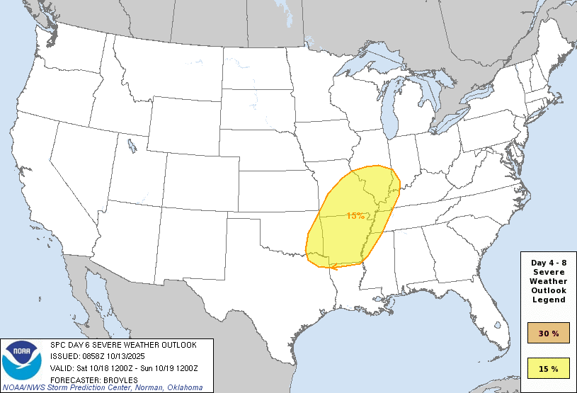
Saturday’s Severe Weather Setup: What to Know & When to Care (Oct 18)
A classic fall pattern sets the stage for thunderstorms Saturday into Saturday night. Here’s the straight talk on timing, hazards, and confidence.
Quick take
- Storm chances rise Saturday afternoon into Saturday night as a front pushes in from the west. In southeast Oklahoma (Broken Bow/McCurtain Co. as a regional example), recent forecasts show around 40–50% odds for thunderstorms Saturday into Saturday night.
- Confidence in exact placement is medium–low right now. Longer‑range outlooks often flag “predictability too low” at this lead time when models don’t agree. Translation: timing looks likely; the most intense corridor will be refined later.
Hazards on the table
- Damaging wind gusts with any organized line or clusters ahead of the front.
- Large hail in any more isolated storm that finds better instability.
- A brief tornado can’t be ruled out if a storm rides a boundary with favorable low‑level winds. This detail is low‑confidence several days out.
Timing (broad brush)
- Saturday afternoon: Scattered storms develop.
- Saturday evening/night: Coverage increases as the front arrives; this is typically the better window for a few severe reports.
What to watch between now and Saturday
- Moisture return: Do dew points surge enough to fuel robust updrafts?
- Wind shear overlap: Does the “spin + storm fuel” line up at the same time?
- Frontal speed: Faster front = earlier storms; slower = more nighttime action.
Prep checklist (simple & smart)
- Enable Wireless Emergency Alerts on your phone.
- Have at least one reliable warning source (NOAA Weather Radio, trusted app, or local TV).
- If you’ll be outdoors Saturday evening, identify sturdy shelter ahead of time.
- Avoid risky behavior (driving through flooded roads, storm chasing without training). Safety > stunts.
Sources
For latest updates as the event approaches, check official forecasts:
