Monday Severe Weather Setup: Heads-Up for East Texas & the ArkLaTex
Posted for Monday, November 24, 2025
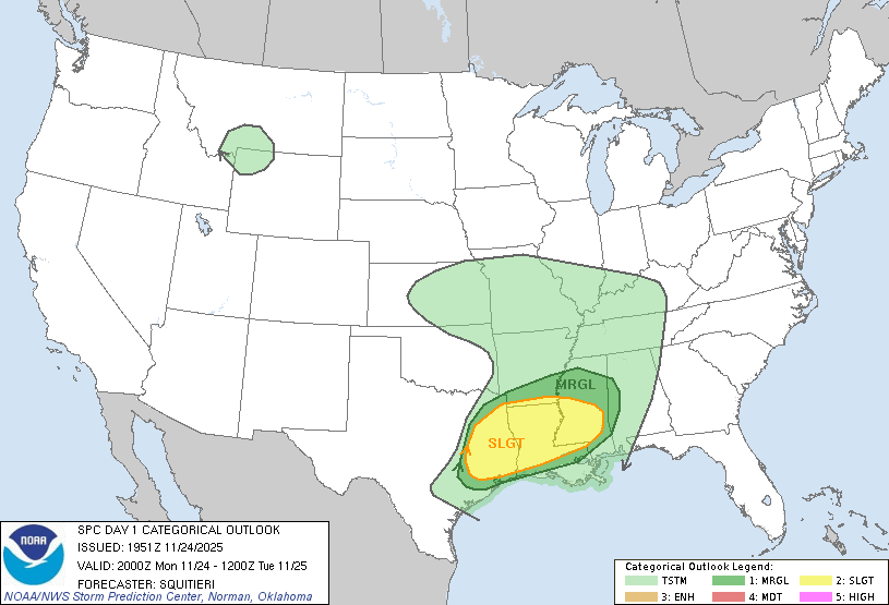
We’re watching the setup for Monday, November 24, 2025, as the atmosphere lines up for another round of storms from east Texas into the ArkLaTex and Ark-La-Miss region.
The Storm Prediction Center (SPC) has placed this zone in a Level 2 of 5 – Slight Risk for severe thunderstorms, mainly from Monday mid-afternoon through Monday night. A few storms could become strong to severe, with the potential for damaging winds, large hail, and a few tornadoes.
Our local area in and around southeast Oklahoma / northeast Texas / southwest Arkansas sits near this zone, so we’ll be watching how far northwest the stronger storms can develop and track.
Key Messages
- Scattered severe storms are possible Monday afternoon and evening.
- A few tornadoes can’t be ruled out, especially farther southeast into east Texas and the Ark-La-Miss region.
- Damaging wind gusts and large hail will also be on the table with stronger storms.
- Heavy rain and frequent lightning may cause localized flooding where storms train over the same areas.
Timing
Exact timing will still wiggle around, but here’s the general idea:
- Mid-afternoon (around 2–4 PM): Storms begin to fire in parts of east Texas.
- Late afternoon to evening (roughly 4–10 PM): Stronger storms organize and move east/northeast toward the ArkLaTex and Ark-La-Miss region.
- Late night: Storms may continue east with a gradually decreasing severe threat overnight.
Locally, we’ll be watching for any clusters or lines of storms pushing toward southeast Oklahoma and the surrounding region later in the day, especially if instability hangs on into the evening.
What Could Go Wrong (In Weather Terms)
The main question marks right now:
- How unstable we can get: If clouds and earlier showers hang around too long, that might limit how intense storms can become near the northern edge of the risk area.
- Exact track of the strongest storms: A small shift north or south will decide who sees the highest tornado/wind threat.
Even with those questions, the broader signal is there for multiple storms to reach severe levels in the Slight Risk area.
How to Get Ready
- Have a way to receive warnings: Weather radio, Wireless Emergency Alerts on your phone, or a trusted app.
- Know your safe place: Lowest floor, interior room, away from windows — especially if a tornado warning is issued.
- Charge devices & check flashlights in case strong winds knock out power.
- Secure loose outdoor items (trash cans, decorations, etc.) that could blow around in strong winds.
Final Thoughts
This does not guarantee a huge outbreak, but the environment supports scattered severe storms, and a few could be significant, especially to our south and east.
We’ll be watching model trends and updated SPC outlooks tonight and Monday morning. As always, use WeatherPower for quick, easy-to-read visuals, but rely on official warnings from the National Weather Service when severe weather threatens.
Stay weather-aware, and we’ll keep you updated as tomorrow’s setup comes into better focus. 🌩️